Projects
You’re here! On this page, we present an in-depth exploration of the projects and research initiatives that geo:truth team has meticulously crafted and shaped across their entire project life cycle. If you would like to know more or are interested in collaborating, guiding or providing us feedback, we welcome and appreciate it.
Your feedback and support helps motivate us and lets us know that our work is resonating with like-minded folk! Send us an email, let us know how we are doing: admin@geotruth.org!
(ongoing) Support Sudan & Diaspora-Owned Businesses and Projects Dashboard
Background | The war in Sudan has profoundly impacted millions, with over 25 million Sudanese forced to flee their homes and approximately 50% of the population losing their jobs. This crisis has devastated livelihoods, making it increasingly challenging for families to survive and rebuild.
Purpose
Create an interactive dashboard that highlights Sudanese-owned businesses, both in Sudan and among the diaspora, to promote recovery and support for affected communities.
Facilitate users in discovering and supporting Sudanese and diaspora-owned businesses, contributing to their revitalization and sustainability.
Encourage community engagement by providing a platform for users to add and promote businesses, fostering growth and visibility.
By supporting businesses on this dashboard, you are playing a vital role in helping families and businesses recover from the conflict and rebuild their communities during these challenging times.
(ongoing) Estimating the Number of Measles-Susceptible Children in Georgia
Background | Measles remains a significant public health threat, particularly among under-vaccinated children. In Georgia, efforts to improve measles vaccination coverage are critical in preventing outbreaks and protecting vulnerable populations.
Purpose
Develop an interactive geospatial model to estimate the number of measles-susceptible children across Georgia, using vaccination coverage, birth rates, and demographic data.
Identify high-risk areas and populations, enabling targeted immunization strategies to reduce susceptibility to measles.
Provide insights to public health officials and stakeholders to inform evidence-based decision-making and resource allocation for vaccination campaigns.
Findings
- The findings from the data analysis will be used to engage public health stakeholders and develop interactive dashboards to explore the data, view trends, and generate reports. The insights gained will inform the planning of targeted vaccination campaigns in identified high-risk areas. (Coming soon!)
Main Researcher: Amaka Mgboh️
| Data + Support - Thank you:
Hubert Department of Global Health, Rollins School of Public Health, Emory University | Georgia Department of Public Health | Georgia Registry of Immunization Transactions and Services (GRITS) | Emory University
(ongoing) Mapping Health Disparities Among Black Women in the United States: A Geospatial Epidemiology Approach
Background | Black women in the United States experience significant health disparities influenced by socio-economic, environmental, and healthcare access factors.
Purpose
Identify geographic hotspots of health disparities among Black women.
Examine the intersectionality of race, gender, and socio-economic status in health outcomes.
Assess environmental and neighborhood-level factors contributing to health inequities.
Main Researcher: Rasha Elnimeiry️
(ongoing) Armed Conflict Sudan: Depth of Understanding Underlying Patterns and Events
Background | The war in Sudan (April 2023) has been marked by decades of civil conflict stemming from ethnic, religious, and political tensions, leading to widespread violence, displacement, and humanitarian crises.
Purpose
Analyze how the spatial distribution of conflict events changes over time.
Identify and classify different types of conflict clusters.
Assess the degree to which conflict events are clustered or dispersed by actors.
Main Researcher: Rasha Elnimeiry️
(completed) Spatial Analysis: Interplay between Armed Conflict, Livelihood, Environmental Factors and Malaria Risk in Sudan
Background | There are complex interrelationships between armed conflict, livelihood patterns, environmental factors, and malaria risk across Sudan.
Purpose
Analyze the spatial impact of armed conflict events on malaria prevalence.
Investigate how different livelihood zones, including Central Rainfed Millet and Sesame and Western Wadi Cultivation, influence malaria vulnerability.
Examine the role of environmental factors, such as soil degradation and urbanization, in shaping malaria risk patterns in Sudan.
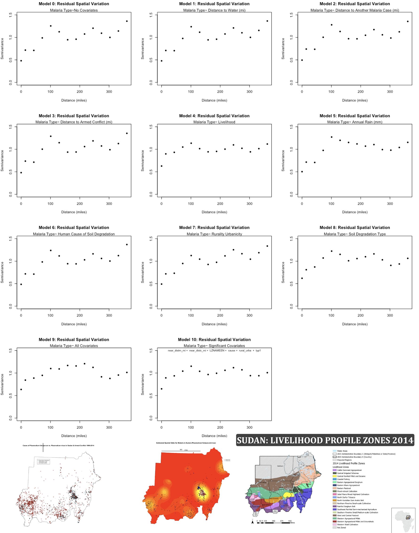
Findings
Distance to Another Malaria Case: Close proximity to another malaria case significantly increased the risk of acquiring the disease, as expected [1].
Distance to an Armed Conflict Event: Armed conflict is a key factor in malaria risk due to indirect impacts like population displacement, poor governance, lack of health services, and environmental degradation. These factors, tied to socio-political issues, exacerbate health risks for affected populations [2][3].
Livelihood Zones:
Northern Riverine Small-scale Cultivation: This zone is near rivers, where fertile land supports agriculture, making it ideal for malaria vector breeding. The fertile soil and irrigation systems can create stagnant water pools, providing breeding grounds for mosquitoes.
Central Rainfed Millet and Sesame: This zone relies on rain for agriculture in regions like Kordofan, which is susceptible to malaria due to water-dependent farming.
Western Wadi Cultivation: Relies on rain and natural water springs, with stagnant pools forming potential mosquito breeding sites.
Human Causes of Soil Degradation – Overgrazing and Agriculture: Agriculture and livestock are vital to Sudan’s economy, with overgrazing and poor agricultural practices leading to soil degradation. This degradation contributes to malaria risk, as compacted soil forms water puddles that provide breeding grounds for mosquitoes [6].
Urbanicity/Rurality: Urban areas, surprisingly, showed higher malaria risk. In cities like Khartoum, urbanization blends agricultural practices with urban infrastructure, creating environments where mosquitoes breed in urban drainage systems and air conditioners. Compact living and increased nighttime activity also increase exposure to malaria [4][5].
Soil Degradation Type: Regions with “stable permanent agriculture” and “compaction” were significant predictors of malaria risk. Soil compaction from agricultural machinery decreases porosity, creating stagnant water pools that serve as mosquito breeding sites [6].
[1] (Elgali, Mustafa, & Bauer, 2010)
[2] (UNEP, 2008)
[3] (Mboera, Mfinanga, Karimuribo, Rumisha, & Sindato, 2014)
[4] (Noor, et al., 2014)
[5] (WHO-EMRO, 2017)
[6] (FEWS NET, 2015)
Main Researcher: Rasha Elnimeiry️
Global Assessment of Human-induced Soil Degradation (GLASOD) | FEWS NET | Malaria Index Survey Sudan | Armed Conflict Location and Event Data Project (ACLED) | Ministry of Health Sudan | Mustashfa Al Manateq AlHarra (Hospital of Tropical Diseases)